rivers Southeastern
Anatolia
Türkiye
If you want to escape the sun, sea and sand holiday makers and experience Türkiye’s more traditional side, then this is the region for you. A crossroads of civilizations since biblical times and much earlier. Recent discoveries at Göbekli Tepe have led to a complete re-evaluation of early human settlements, the mighty Euphrates and Tigris Rivers rise here, the Syriac monasteries in Mardin and Midyat still chant in Aramaic. The summers are long and dry. As the region is perfect for agriculture, you won’t be surprised that the best kebabs and vegetables are part of everyday life as you feast on the local cuisine.
The Eastern Anatolian region has rich water sources because the Euphrates, the Tigris, the Çoruh, the Aras and the Kura rivers originate here and flow into the sea in other countries.
The Tigris–Euphrates river system is a large river system in Western Asia which discharges into the Persian Gulf. Its principal rivers are the Tigris and Euphrates along with smaller tributaries.
The two main rivers in this region – the Euphrates and the Tigris – are at the very heart of our history. Not that of the birth of humankind, but that of early civilizations and the first significant advances, such as the appearance of the first method of writing and the first known religions.
Some of the great civilizations of the History of Humanity grew here or came here. These overlapping levels of cultural, religious and ethnic influence created a complex mosaic with diverse peoples sharing the same region.
Euphrates River (Fırat)
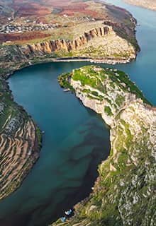
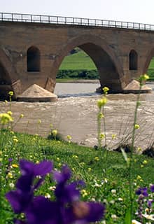
The Euphrates River is the longest and one of the most historically important rivers of Western Asia. The Euphrates (Firat in Turkish) is 2,800 km long, out of which 1,263 km is in Türkiye. It emerges from the confluence of the Kara Su (ancient Arsanias) or Western Euphrates (450 km) and the Murat Su or Eastern Euphrates (650 km) 10 kilometres upstream from the town of Keban in South Eastern Türkiye. Originating in the Armenian Highlands of eastern Türkiye, the Euphrates flows through Syria and Iraq to join the Tigris in the Shatt al-Arab, which empties into the Persian Gulf.
As well as Karasu and Murat, other tributaries of the Euphrates include: the Tohma, Peri, Calti and Munzur rivers. Average elevations along the Euphrates range from 760 m for the lowlands to more than 1,500 m for the plateaus and mountains. Its water regime depends heavily upon winter rains and Spring snowmelt in the mountains; it grows between March-June when the snow in the mountains melt and reduces its water flow between July-January when there isn't much rain due to the typical continental subtropical climate (hot and dry summers, cold and snowy winters). The river collects most of its water from rainfall and the defrost that happens at the end of each winter, reaching maximum flow in April and May.
The agriculture along the Euphrates holds an important part in the economy of the region, which comes to a halt during the winter because of freezing temperatures and snow. Fishing is another important income for the locals living around the Euphrates. As for the fish and other animals in the river and marshes, we can count carp, barbels, catfish, spiny eel, frogs, toads and turtles. Numerous plants and trees grow near the rivers in the region, such as oak, pistachio, ash forests, cattail, mardi reed and other reeds, camel thorn, prosopis, willow, poplar, date palm, and some wildflowers.
- River Dams on the Euphrates
- The Keban Dam is one of the biggest in Türkiye (210 m and was built between 1965-1975. Another big dam is Karakaya (173 m) which was opened in 1987 as part of the GAP Project, and other dams include Birecik and Karkamış.
- But the largest dam of Türkiye in size, and one of the biggest dams in the world, is the Ataturk Dam which is also on the Euphrates river near Şanlıurfa province built between 1983-1992; it's 169 m high. All of these dams were constructed to provide hydroelectric power to this region of Türkiye, provide water for irrigation, and help with flood control. These dams have large and distinct reservoirs as well. The water from the Ataturk Dam passes through two parallel 7.62 m wide and 26.4 km long tunnels near Urfa and is used for the irrigation of the agricultural fields in Urfa-Harran, Mardin-Ceylanpınar, Siverek-Hilvan, and the upper Mardin areas.
- Historical Significance
- Together with the Tigris, it is one of the two defining rivers of Mesopotamia (the "Land between the Rivers"). The Euphrates River, as well as the neighbouring Tigris River, played an essential role in the development of the civilizations that started in Mesopotamia and marked the beginning of history.
- Sumer, Assyria, Babylon gave way to Persia and to the different dynasties that ruled there. Probably none of this would have been possible without the fertilization of those lands that was caused (and still is) by these rivers.
- On its banks are some of the oldest cities of the region and a traveller will surely come across its winding waters several times.
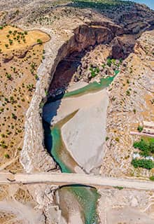
Tigris River (Dicle)
The Tigris River is the eastern of the two great rivers that define Mesopotamia, the other being the Euphrates. The river flows south from the mountains of the Armenian Highlands through the Syrian and Arabian Deserts and empties into the Persian Gulf.
The Tigris is 1,900 km long, out of which 523 km is in Türkiye. It rises in the Taurus Mountains of eastern Türkiye about 25 km southeast of the city of Elazığ and about 30 km from the headwaters of the Euphrates.
Mardin is one of the few cities in the world wherein the entire city has been declared a UNESCO World Heritage Site. This is because just about every inch of the city oozes history and culture, and these lands along the Tigris River have been the crossroads of civilizations since the dawn of civilization itself.
The whole province of Şırnak is covered by high mountains, deep river valleys and plateaus. All the rivers are interconnected in the Tigris basin and are tributaries of the Dicle River. The main rivers are: Kızılsu, Hezil and Habur. With the exception of Beytüşşebap and Uludere, the majority of the terrain is steppe. The forests are mainly of oak.
Other important tributaries of the Tigris are Batman, Garzan, Botan and Habur rivers in Türkiye, and Greater Zab and Lesser Zab rivers in Iraq. Its average water flow is 360 m3 per second; around mid-September the flow drops to 55 m3 because of dry summers in the region, and in March it goes up to 2,263 m3 per second because of the winter precipitations and then the snow melts in the Spring. The Tigris is shorter than Euphrates in length but it carries more water, thus it causes lots of flooding especially on the Iraqi side.
There are several hydroelectric power plants on the Tigris, such as Kralkızı (built between 1985-1997), Batman (1986-1999), Dicle (1986-1997) and Ilisu (under construction) Dams. Besides producing electricity, these dams provide water for irrigating agricultural fields in the arid GAP area as well. There are also several dams built on the Tigris on the Iraqi side, Mosul Dam being the largest dam in Iraq.
According to the Book of Genesis, the Tigris (named there as the Hiddekel) was one of the four rivers branching off the river flowing out of the Garden of Eden (Genesis 2:10). These four rivers were Pishon, Gihon, Hiddekel (Tigris) and Perat (Euphrates). In the Book of Daniel the prophet Daniel received his visions near the Hiddekel River (Daniel 10:4).
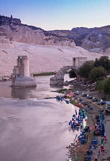
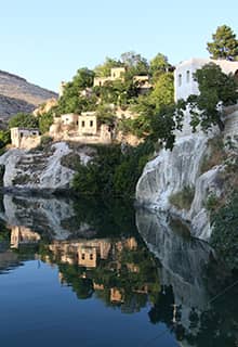
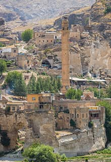
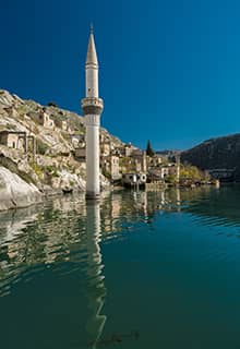
Halfeti, Şanlıurfa
Halfeti is one of the oldest surviving settlements in all of Mesopotamia, and certainly one of the most impressive. Much of the city is under water, part of the effects of climate change and modernization, but much of the history can still be seen under water and 20% of the ancient city still stands above water. The Euphrates River is at its most beautiful in this spot, with stone architecture beneath the surface revealing a hidden paradise. It’s also known as one of the world’s great “Lost Cities” to visit, where you can literally see remains as the waves ripple over them.
Many ancient cities flourished on the banks of Euphrates river during the Hittite and Urartu periods, Zeugma city was one of them. The Euphrates, and Tigris Rivers are both mentioned in the Bible. One of the oldest names of the Euphrates was Perat and it is mentioned in the Book of Genesis (Genesis 2:10-14) as one of the four rivers branching off the river flowing out of the Garden of Eden. These four rivers were Pishon, Gihon, Hiddekel (Tigris) and Perat (Euphrates).